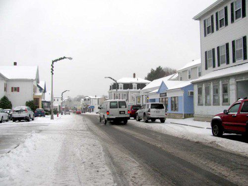
THE FIRST significant snowfall of the winter led to some treacherous roadways for this morning’s commuters. The wintry mix that fell overnight created sloppy conditions on Albion and Pleasant streets.
Published in the December 29, 2015 edition
WAKEFIELD — The first winter storm of the season created slippery conditions during the morning commute across the area and by mid-morning the DPW had its sanders and plows out attempting to keep ahead of the precipitation before a forecasted freeze up later today and tonight.
According to DPW Director Richard Stinson, the wet, heavy snow “was like glue, sticking everywhere” and was difficult to get completely scraped off road surfaces.
The town received less than two inches before it turned to sleet before 9 a.m.
Public works crews used salt to treat streets before snow fell around 2:30 a.m. but that proved futile because there was so much moisture. Town vehicles were used to scrape roadways beginning around 7 a.m., Stinson said, with the plan to salt later today before a refreeze.
“It’s amazing how heavy this is,” Stinson said of today’s snow. “Last year, even when we got a lot of it, the snow was light (because it was so cold). This stuff might be heavier than a 12-inch storm last year.”
The DPW was down to five big sanding machines today because the sixth one was in getting new controls installed, Stinson said, but other than that all snow removal apparatus owned by the town was available for use.
There was no plan to call in a full complement of contractors; Stinson did say, however, that a couple of private Bobcats might be hired to handle difficult private ways and to get into tight areas on properties like the McCarthy Senior Center on Converse Street.
This is the first winter storm since the selectmen and Town Meeting decided to do away with the traditional overnight parking ban on Wakefield streets between December and April. Stinson reported few if any difficulties, since the bulk of snow was cleared during the day and there are no snowbanks yet that narrow streets.
“We will plow or salt around everything like in past years,” the DPW chief explained. “Besides, it is supposed to be OK for the next couple of weeks. The sun will warm up and melt what is left over. The temperatures won’t be very high but the sun will still do some melting. Tomorrow’s supposed to be between 41 and 46 degrees during the day.”
Stinson explained that smaller storms like today’s provide good training for his crews, even more so this year because of a higher than normal number of new workers.
According to the state’s Emergency Management, the season’s first winter storm will impact the state through the day today. Snow, sleet and freezing rain in the interior had a high impact on the morning commute.
Snowfall totals will range from 1” to 3” along and north of the Massachusetts Turnpike to up to 2” to 4” in places along and north of Route 2.
Some areas of interior southern Massachusetts may receive up to an inch of sleet this morning. There could be 1/4 to 1/2 inch of ice accretion over the east slopes of the Berkshires, up to 1/4 inch of ice in the rest of western and central Massachusetts and up to 1/10 inch of ice in the rest of interior Massachusetts. Scattered power outages are possible over the east slopes of the Berkshires with isolated power outages possible over other portions of interior Massachusetts.
A Winter Weather Advisory is in effect until 7 p.m. this evening for all of Massachusetts except the Cape and Islands and Southern Bristol and Plymouth counties.
During the morning commute, snow transitioned to sleet and freezing rain from southwest to northeast over interior Massachusetts and to rain near the coast. Freezing rain will persist through the day in interior Massachusetts. There is potential for light freezing rain or freezing drizzle to recur across portions of northern and northeastern Massachusetts toward this evening. This could cause some impact to the Tuesday evening commute in those areas and, if it persists, to the Wednesday morning commute as well.
Untreated roads may become slick and slippery with only a trace of snow and/or ice. Visibilities will be reduced, especially during periods of snowfall. Isolated to scattered power outages will be possible where the greatest ice accumulations occur, particularly across portions of the east slopes of the Berkshires.
The speed limit on the Massachusetts Turnpike was reduced to 40 MPH from the New York border to Exit 9 in Sturbridge.
MEMA received reports of vehicle spinouts and jack-knifed tractor trailers on multiple highways around the Commonwealth. MassDOT and MSP are working quickly to keep traffic flowing.


